I'm

Tendai Davies Makoni

GIS Specialist, Information Management Officer, Cartographer, Environmentalist
Hero Image
Image

Learn About Me

10 Years Experience

I am a passionate geospatial technology professional with over 8 years of diverse experience delivering impactful GIS and data-driven solutions across agriculture,telecommunications, mining, humanitarian, and environmental sectors. My expertise spans the full GIS lifecycle—from data capturing, georeferencing, and digitizing, to advanced spatial analysis, database management, and visualization. I have successfully led multiple projects involving custom GIS application development, data automation, and integration, consistently ensuring data quality and integrity. Throughout my career, I have supported organizations and communities by transforming complex geospatial data into actionable insights—building dashboards, interactive maps, and reports that empower smarter decision-making. I have also mentored teams and fostered collaborative environments where innovation and technical excellence thrive. With a strong focus on real-world impact, I bring both technical depth and strategic vision to every project. I am always eager to connect, learn, and collaborate with professionals who share a passion for leveraging geospatial intelligence to solve complex challenges and drive sustainable development.

GIS & Data Services

95%

Data Analysis & Information Management

95%

Research and Consultancy

85%

Business Intelligence

85%

Learn More

What I do

Smart Mapping for a Smarter World- Mapping Solutions That Drive Action

GIS & Data Services

Cartography & Map production
Georeferencing & Geocoding
Operational GIS Database Management
Remote Sensing
GIS Training
GIS Technical Support

Data Analysis & Information Management

Designing data collection tools
Data collection services
Data cleaning, profiling & validation
Data storage/Warehousing
Data analysis & visualisation
Data Reporting

Research and Consultancy

Environmental Impact Assessment
Baseline Survey
Monitoring & Evaluation

Business Intelligence

Geo-marketing
Market analysis
GIS Strategic Action Planning
Product Analysis
Market Segmentation

My Resume

Working Experience

2024 -

GIS Adminstrator

Leading Hospitality Services, Abu Dhabi, UAE

🔹 Leading the design, development, and deployment of tailored GIS solutions, tools, and web applications to support strategic planning and operational needs.
🔹 Integrating GIS with enterprise systems to enhance data accessibility and interdepartmental collaboration.
🔹 Creating detailed maps, interactive dashboards, and insightful reports to support decision-making across departments.
🔹 Designing Python and SQL scripts to automate data workflows, ensure database synchronization, and streamline spatial data management.
🔹 Managing and maintaining GIS infrastructure, software environments, and licenses across the organization.
🔹 Conducting spatial data audits to validate accuracy, improve data integrity, and support geospatial data governance.

2022 - 2022

Information Management Officer- Consultant

Norwegian People's Aid / Norsk Folkehjelp, Mutare, Zimbabwe

🔹 Managed program data systems by ensuring all key documents and reports were correctly uploaded and maintained on SharePoint.
🔹 Updated and maintained GIS maps to track program progress and operational coverage.
🔹 Ensured timely access to accurate, up-to-date information to support informed decision-making processes.
🔹 Maintained and structured GIS datasets, operational databases, and spatial layers in a hierarchical, consistent format.
🔹 Conducted data quality control, verifying accuracy, completeness, and consistency of submitted field data.
🔹 Provided frontline technical support for hardware, software, and network-related issues affecting data workflows.
🔹 Assisted in the analysis of spatial and operational data to support planning and reporting needs.

2022 - 2025

GIS Consultant

Mining Connect (Pvt) Ltd, Harare, Zimbabwe

🔹 Performed GIS and remote sensing data preprocessing including data capturing, georeferencing scanned maps, resampling, and digitizing mine claims with attribute updates.
🔹 Delivered regular status reports to management on data management activities and data protection initiatives.
🔹 Ensured data quality and integrity through thorough validation, cleaning, and profiling processes.
🔹 Conducted data protection audits and risk assessments to identify vulnerabilities and recommend improvements.
🔹 Provided spatial data analysis and reporting to support operational and strategic decisions.
🔹 Led GIS project planning and execution, coordinating cross-functional efforts to meet project goals.

2018 -

Director

Scion Pvt Ltd, Harare, Zimbabwe

🔹 Spearhead the design, development, and implementation of customized GIS and remote sensing projects, leveraging expertise in data capturing, georeferencing, digitizing, and spatial analysis.
🔹 Lead the creation and management of robust geospatial databases to ensure high data quality, integrity, and accessibility for decision-making.
🔹 Provide strategic consulting services to clients, translating complex geospatial data into actionable insights through detailed maps, reports, and visualizations.
🔹 Oversee project planning and execution, coordinating multidisciplinary teams and managing client relationships to deliver impactful results on time and within scope.
🔹 Drive innovation by integrating GIS technology with emerging tools and methodologies to address evolving industry challenges.
🔹 Mentor junior staff and foster a collaborative culture of learning, creativity, and technical excellence within the company.

2017 - 2022

GIS Consultant

SkyArt Investments, Harare, Zimbabwe

🔹 Produced accurate and visually impactful maps through advanced cartographic techniques and spatial analysis.
🔹 Provided consulting services on land-related geospatial issues, supporting informed decision-making for audits and planning.
🔹 Participated in land audits, capturing, verifying, and analyzing spatial data to assess land usage and compliance.
🔹 Conducted data capturing, including digitizing and georeferencing of spatial features from remote sensing imagery and scanned maps.

2015 - 2022

GIS and Data Consultant

Technical Systems , Harare, Zimbabwe

🔹 Collected, digitized, and georeferenced spatial data through desktop methods and field surveys (GPS/ODK).
🔹 Ensured high data integrity through rigorous quality monitoring, data cleaning, and validation protocols.
🔹 Designed and managed spatial and non-spatial databases to support diverse project needs.
🔹 Conducted advanced data analysis and visualization to inform decision-making and reporting.
🔹 Produced accurate and visually compelling maps, dashboards, and cartographic outputs tailored to project objectives.
🔹 Developed custom mobile data collection tools using Open Data Kit (ODK) to streamline field data acquisition.
🔹 Supervised and mentored students and interns, providing training on GIS tools, data collection, and spatial analysis.

From Blog

Latest Articles

Blog

From Data to Decisions

Admin

Data Analysis and Information Management

16-Jul-2025

5

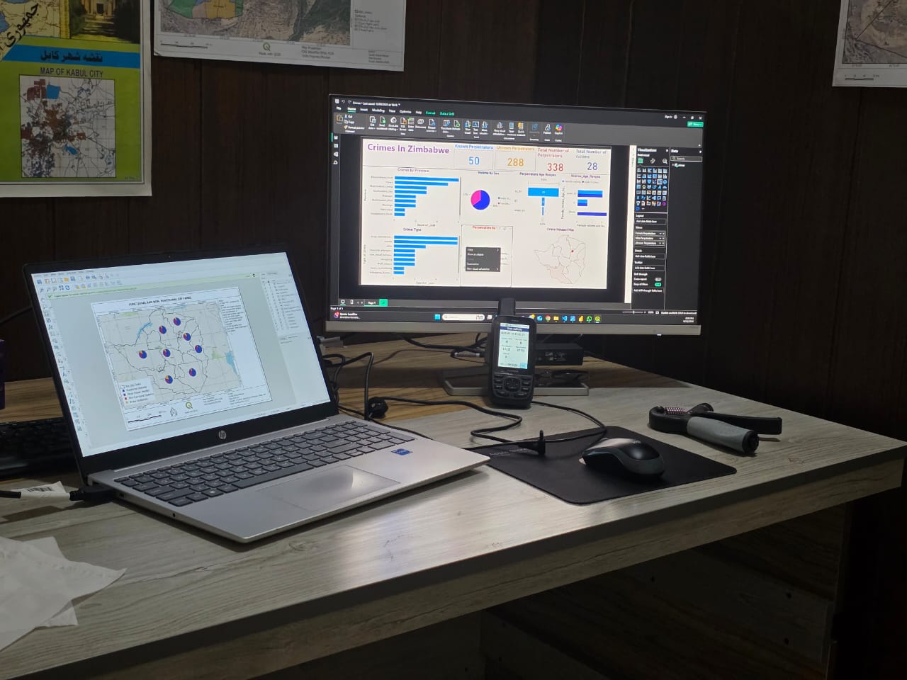
KoBo Collect and Power BI are powerful tools for crime data collection and analysis. KoBo Collect enables field officers or community members to capture crime reports in real time, even in remote areas without internet access. It supports customized forms with GPS, timestamps, and severity ratings, ensuring accurate and consistent crime data collection. Power BI complements this by turning raw crime data into interactive dashboards and visual reports. It allows users to analyse trends over time, map crime hotspots, compare incidents by district, type, or gender, and monitor severity levels. Together, these tools provide a complete solution—from capturing crime incidents in the field to analyzing patterns and informing decision-makers. This integration enhances responsiveness, supports strategic policing, and helps allocate resources effectively. For crime analysis, KoBo Collect and Power BI improve transparency, data accuracy, and timely reporting, enabling smarter crime prevention and public safety planning.

Read More
Blog

Mapping Solutions That Drive Action

Admin

Data Analysis and Information Management

01-May-2025

7

Ticks are blood-feeding parasites that transmit diseases like Lyme disease, anaplasmosis, babesiosis, and Rocky Mountain spotted fever to humans and animals. These illnesses often cause fever, fatigue, rash, and joint or muscle pain. Ticks thrive in grassy or wooded areas and are most active in warm weather. Preventing tick bites involves using repellents, wearing long clothing, and checking for ticks after outdoor activity. In livestock and pets, regular dipping using acaricides is an effective method to control tick infestations and reduce disease risk. Early detection, prompt tick removal, and consistent preventive practices help minimize the impact of tickborne diseases.

Read More